

DALLAS COUNTY TRAIL SYSTEM
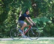
Over the past decade, trails have become one of the most popular recreational amenities in the U.S. Couples use them to take walks together, parents use them to teach their children how to ride a bicycle, and other use them to help lose weight, stay in shape, train for a race, or as a means by which they can get to work, to school, or to the store.
Not surprisingly, studies have shown that trails enhance local property values and can do much to attract residents, tourists, and busineses; reduce traffic; and improve air quality.
Because of these important benefits, Dallas County and many of its cities have been actively working to create a comprehensive trail system in the Dallas area. It is our goal to have a system that connects work places, neighborhoods, retail areas and other major destinations, and that enables people to safely walk, run, bike, or skate from one end of the County to another--a distance of at least thirty miles--without the need of a car.
There are currently over 150 miles of major hard surface trails (i.e., trails with a width of at least eight feet and a length of at least 1.5 miles) and 17 miles of dedicated bike lanes in Dallas County. These trails and bike lanes are located in the cities of Dallas, Richardson, Irving, Grand Prairie, Carrollton, DeSoto, Lancaster, Mesquite, Addison, Farmers Branch, and Garland, and they make it possible to reach major employment centers like Las Colinas and the Telecom Corridor, to connect with DART light rail stations, to enjoy views of White Rock Lake, Bachman Lake, and the Trinity River, to see concerts and sporting events at the American Airlines Center, to reach SMU or the University of Texas at Dallas, and to travel from beyond the County's border to downtown Dallas.
The County and its cities are also presently in the process of designing and constructing another twenty-five miles of trail which should be completed within the next two-to-three years. These projects, among others, will involve extending the already popular Katy Trail, building the first major trail in West Dallas (Chalk Hill), and extending what will become the Dallas area's most significant east-west trail (Northaven).
Information about each of the currently existing trails (including maps, distances, photographs, key features, and destination points) is available through the menu on the leftside of this webpage as is information about other upcoming projects and local trail plans.
Further information can also be obtained by calling Dallas County at (214) 653-7601 and by visiting Twitter (@DallasCoTrails) or Facebook (Dallas County Trails and Preserves).
| Download | Print Format |
| Map of Major Dallas County Trails |
 |  |  |
 |  |  |
-
You must be on the network to see these links.
© 2026. Dallas County. All rights reserved.